Agricultural Mitigation Bank
Wetland Mitigation for Agriculture at the Reuthinger Wetland Mitigation Bank
2023 Mitigation Agreement (PDF)
The Wood County Park District’s J.C. Reuthinger Memorial Preserve, is located in Perrysburg Township, north of Reuthinger Road near Perrysburg, Ohio in the Otter Creek watershed (a direct tributary of Lake Erie) which flows approximately 7.5 miles to the Maumee Bay. The Reuthinger family land was originally part of the Great Black Swamp, which included the Portage River basin and large portions of the Maumee River watershed.
Wetland restoration and development of the thirty-acre Reuthinger Wetland Mitigation Bank will be implemented with grant funding provided by the United States Department of Agriculture (USDA) Natural Resources Conservation Service (NRCS) and operated for the exclusive use of agricultural producers that need to maintain eligibility or resolve compliance issues under the wetland conservation provisions of the Food Security Act (FSA) (16 U.S.C. §3801 et seq.).
Agricultural producers may maintain compliance or resolve compliance issues through the purchase of wetland credits at the Reuthinger Wetland Mitigation Bank. Initially, 4.5 wetland credits will be available for sale with additional credits approved for sale by NRCS as the mitigation bank meets its performance objectives. Forested credits are $30,000 per credit and nonforested credits are $14,000 per credits. Credits are sold in whole tenths.
 Agricultural producers located within Northwest Ohio which propose to mitigate for eligible wetland impacts should first request a wetland determination from their local USDA Farm Service Agency. After a certified wetland determination is completed, the NRCS will develop a separate mitigation agreement for the proposed purchase of credits. The NRCS point of contact for mitigation eligibility is Nick Schell, NRCS State Biologist, 614-255-2490, or email, nick.schell@oh.usda.gov. Agricultural producers located within Northwest Ohio which propose to mitigate for eligible wetland impacts should first request a wetland determination from their local USDA Farm Service Agency. After a certified wetland determination is completed, the NRCS will develop a separate mitigation agreement for the proposed purchase of credits. The NRCS point of contact for mitigation eligibility is Nick Schell, NRCS State Biologist, 614-255-2490, or email, nick.schell@oh.usda.gov.
The primary service area consists of the USGS Hydrologic Unit Code (HUC) #04100010 (Portage River) and the portion of the USGS HUC #04100009 (Maumee River) located in Wood County, Ohio. The secondary service area includes the following: USGS HUC #04100001 (Ottawa River), #04100002 (Raisin River), #04100003 (St. Joseph River), #04100004 (St. Marys River), #04100005 (Upper Maumee River), #04100006 (Tiffin River), #04100007 (Auglaize River), #04100008 (Blanchard River), #04100009 (the rest of the Maumee River basin located outside of Wood County), #04100011 (Sandusky River) and #04100012 (Huron/Vermilion River).
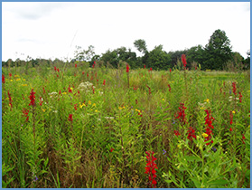
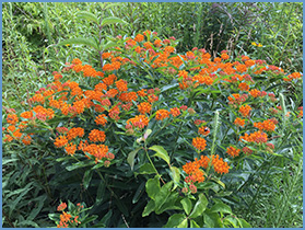
Restoration will add emergent/wet prairie and forested wetland habitats, important habitat for wildlife (mammals, birds, amphibians, reptiles, insects/invertebrates) and potential feeding, breeding, nesting and rearing habitats, as well as migratory pathways with connections to small areas of woodlands in the vicinity of the Reuthinger Wetland Mitigation Bank. Wetland restoration at this site will also support the objectives of the NRCS and United States Fish and Wildlife Service to contribute to the habitat requirements of the monarch butterfly. The seed matrix includes host and nectar plants for the monarch (Danaus plexippus) and nectar and cover plants for the rusty patched bumblebee (Bombus affinus), an endangered species. Both of these species were historically found in or migrate through Wood County, Ohio.
The stewardship department of the Wood County Park District, a greenhouse and a native plant nursery are located within the J.C. Reuthinger Memorial Preserve. The restored wetlands at the Reuthinger Wetland Mitigation Bank will be adjacent to these park facilities, which are available for public use and can be used for environmental education, including FFA, FSA or farm bureau programs. |